10 May 2026 · 2 min read
The Ice That Carved a Strait: The Bassian Plain
During the last glacial maximum, sea levels dropped 120 metres, exposing the Bassian Plain—a land bridge connecting Tasmania to the mainland where now the cold waters of Bass Strait flow.
The Bass Strait is a lie. It appears permanent, a cold sweep of water between mainland Australia and Tasmania. But walk its floor in your imagination and you cross a drowned plain, 240 kilometres wide, where river channels still trace their paths beneath the waves. This was dry land, and recently—geologically, a blink ago.
The Bridge That Rose and Fell
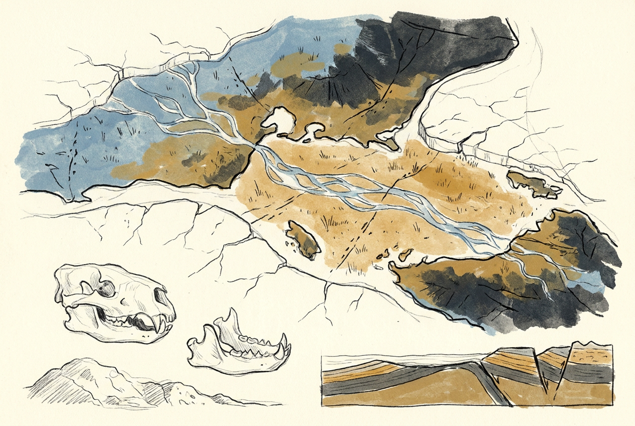
During the last glacial maximum, roughly 20,000 years ago, sea levels stood 120 metres lower than today. The Bassian Plain, as geologists call it, emerged as a broad land bridge connecting Victoria's Wilsons Promontory to Tasmania's Cape Portland. The coastline then lay near the edge of the continental shelf, where the seabed now drops abruptly into the Tasman Basin.
The plain was not a barren isthmus. Pollen cores from the Bass Strait seafloor, drilled by the research vessel Rig Seismic in the 1980s, preserve the remains of alpine grasslands and scattered woodlands. Kangaroos, wombats, and wallabies crossed freely. The ancestors of Tasmania's thylacine and devil walked this corridor. So did people: the first humans reached Tasmania around 40,000 years ago, across this same invisible bridge.
The Drowning
Around 14,000 years ago, the ice sheets began to melt. The sea rose, at times as fast as one metre per century. The Bassian Plain shrank, became a narrowing corridor, then broke into islands—King Island, Flinders Island, the Furneaux Group—and finally vanished beneath the waves about 8,000 years ago.
The drowning must have been visible within a human lifetime. Shorelines advanced kilometres inland over decades. The Bass Strait was born, and Tasmania became an island. The people and animals that remained on the Tasmanian side were cut off, beginning 8,000 years of isolation that shaped their culture, their genetics, and their ecology.
The Bassian Plain survives only as a ghost geography: submarine channels, drowned dunes, and the scattered islands that were once its hilltops.
What the Strait Preserves
The seabed of Bass Strait still holds the plain's fingerprints. Sonar mapping reveals ancient river valleys—the Bass River system—cut into the continental shelf. Near King Island, submerged sand dunes, formed by wind during the glacial period, remain intact beneath a thin veneer of modern sediment.
Fossil bones dredged up by fishermen tell the rest of the story. Mammoth kangaroos, diprotodons, and the marsupial lion Thylacoleo carnifex have been pulled from the strait's floor, their skeletons preserved by cold saltwater. These were animals of the plain, not the sea. Their presence confirms that Bass Strait is not a permanent feature but a temporary flood, a high-water mark in the long pulse of ice ages.
A Future Bridge?
The Bassian Plain will return. The mathematics of Milankovitch cycles—the wobbles in Earth's orbit that drive glacial periods—predict that within 50,000 years, ice will advance again and seas will retreat. The strait will drain, the plain will re-emerge, and Tasmania will rejoin the continent.
That timescale is almost incomprehensible to human planning. But the plain reminds us that Australia's shape is provisional. The coastlines we map, the islands we name, the straits we navigate—these are merely the current frame of a slow, repeating animation. The Bassian Plain waits beneath the waves, patient, ready to rise again.
More like this
- The 110-Million-Year-Old River That Runs Backwards UndergroundWestern Australia's 110-million-year-old dune system has been slowly dissolving into a labyrinth of caves where an ancient river still flows, carrying the taste of a Cretaceous desert.
- The 5,000-Year-Old Volcanoes That Still Smoke in the SouthIn Victoria's Newer Volcanics Province, 400 volcanic vents erupted as recently as 5,000 years ago—the youngest volcanic field in mainland Australia, where craters still hold blue lakes and scoria cone
- The 1.75-Billion-Year-Old Reef That Outranks the BarrierA 1.75-billion-year-old microbial reef in the Kimberley is the largest biological structure ever built by a single species, preserving a world without predators.