9 May 2026 · 3 min read
The Fossil River: The Cretaceous Channels of the Ceduna Delta
Deep beneath the Great Australian Bight, a 100-million-year-old river system—the Ceduna Delta—preserves 12 cubic kilometres of sediment and a record of Antarctica's final separation.
Off the coast of South Australia, beneath two kilometres of seawater and another four kilometres of sediment, lies the ghost of a river system that once drained Antarctica.
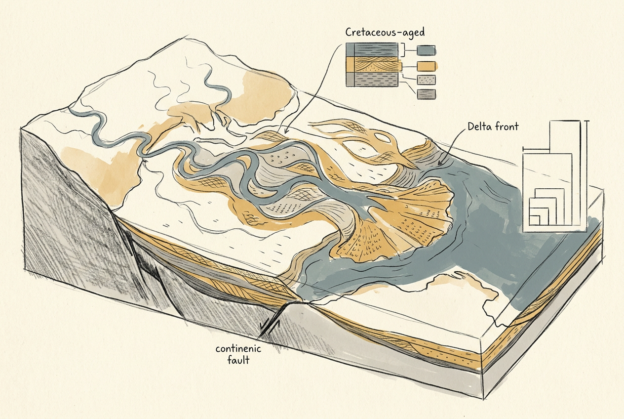
The Ceduna Delta is not visible from the surface. It has no cliffs, no gorges, no dry riverbeds winding across the Nullarbor. It exists only in seismic reflection profiles—sound waves that map buried strata—and in the slender cores drilled from the ocean floor. But this invisible delta, built between 100 and 65 million years ago, is one of the largest sediment accumulations on Earth: roughly 12 cubic kilometres of sand, silt, and clay, stacked in a wedge that stretches 500 kilometres across the continental shelf.
The River That Ran South
During the mid-Cretaceous, Australia was still joined to Antarctica. The two continents formed the eastern edge of Gondwana, and the climate was nothing like today. Where the Great Australian Bight now opens onto cold Southern Ocean swells, a broad coastal plain sloped southward toward a shallow sea. Rivers carrying meltwater from the highlands of what is now Wilkes Land, Antarctica, flowed north across this plain—north, because the geography was inverted, and the continent's interior lay lower than its southern margin.
These rivers converged into a single massive drainage system that emptied into a rift valley—the same rift that would eventually tear Australia and Antarctica apart. The delta they built was not a single lobe but a complex fan of shifting channels, much like the modern Mississippi or Nile. As the continent stretched and thinned, the basin subsided, accommodating kilometre after kilometre of sediment.
The delta grew not outward, but downward—a slow sinking into the widening crack of a continent breaking in two.
The Seismic Archive
Today, the Ceduna Delta is buried under the Bight Basin, a sedimentary trough that formed during Australia's final separation from Antarctica around 45 million years ago. The delta itself stopped growing when the two continents finally parted and the river's headwaters were carried south on the Antarctic Plate, severed from their delta like a limb from its body.
What remains is a fossilised drainage system preserved in cross-section. Seismic surveys reveal the delta's internal architecture: clinoforms—sloping layers of sediment that once marked the delta's front—tilted and stacked like a deck of cards. Some of these clinoforms are hundreds of metres high, recording pulses of sediment delivery during wetter Cretaceous climates. Deep-sea drilling has recovered cores of sandstone and siltstone, some still bearing the organic matter of ancient soils washed down from Antarctica.
The delta also contains petroleum. The same thick sequences of sediment that preserved the river's shape also cooked organic material into natural gas. For decades, the Ceduna Delta was a target for oil exploration—a buried prize beneath one of the world's most hostile seas.
The Unseen Landscape
The Ceduna Delta matters not for what it contains but for what it represents: a landscape that no longer exists, draining a continent that no longer exists, into a sea that was only just beginning to open.
It is a reminder that the geology of Australia extends far beyond the coastline. The continent's edge is not a clean line where land meets water. It is a ragged margin where rifted crust tapers into the deep ocean, and where entire river systems—whole worlds of floodplains and estuaries and deltaic forests—lie buried under the weight of 65 million years of silence.
When geologists map the Ceduna Delta, they are not just tracing ancient channels. They are reading the final chapter of Gondwana's breakup—a slow, patient record written in sand, preserved in stone, and hidden beneath the sea.
More like this
- The 110-Million-Year-Old River That Runs Backwards UndergroundWestern Australia's 110-million-year-old dune system has been slowly dissolving into a labyrinth of caves where an ancient river still flows, carrying the taste of a Cretaceous desert.
- The 5,000-Year-Old Volcanoes That Still Smoke in the SouthIn Victoria's Newer Volcanics Province, 400 volcanic vents erupted as recently as 5,000 years ago—the youngest volcanic field in mainland Australia, where craters still hold blue lakes and scoria cone
- The 560-Million-Year-Old Garden That Never Saw a PredatorIn South Australia's Flinders Ranges, 560-million-year-old Ediacara surfaces preserve entire seafloor communities of fronds, discs, and quilts — a garden of soft-bodied life that flourished before pre