17 May 2026 · 4 min read
The Sandstone That Became a Lake: Western Australia's Bungle Bungle Range
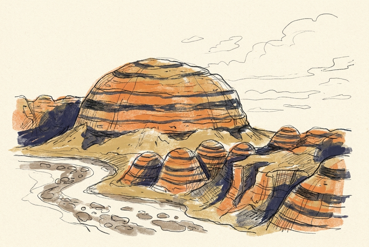
The Bungle Bungle Range in Purnululu National Park preserves 350-million-year-old Devonian sandstone shaped by 20 million years of weathering into orange-and-black banded domes.
From the air, the Bungle Bungle Range looks like a giant beehive the size of a city. The domes rise 300 metres above the plains of Western Australia's Kimberley region, striped in orange and black like a tiger that has lain down to sleep. They are not volcanic, not tectonic, not even particularly old as mountains go. They are sandstone that has been patiently carved by water, wind, and time into one of the most improbable landscapes on Earth.
The Sediment That Never Escaped
The rock of the Bungle Bungles began as sand. Around 350 million years ago, during the Devonian Period, a vast river system carried sediment from highlands to the north and deposited it in a basin that slowly subsided. The sand was buried, compacted, and cemented into the quartz sandstone we now call the Tumblagooda Sandstone.
What makes this sandstone unusual is how little it has changed. Unlike many ancient sandstones that were deeply buried, heated, and recrystallised into quartzite, the Tumblagooda Sandstone remained shallowly buried for most of its existence. It stayed porous, friable, and vulnerable. That vulnerability would become its defining feature.
The sandstone is cross-bedded on a massive scale — individual foresets can be 20 metres thick, recording the migration of giant sand dunes in a Devonian river delta. These ancient dune faces are now preserved as the sweeping curves and slopes of the domes.
The Weathering That Drew the Stripes
The orange and black bands that make the Bungle Bungles famous are not layers of different rock. They are the same sandstone, coloured by two different forms of iron oxide.
The orange bands contain hematite — the same mineral that gives rust its colour. The black bands contain a layer of cyanobacteria, a living microbial crust that grows on the surface where water seeps from the rock. The black is not rock at all; it is biology, a thin film of life that darkens the sandstone where moisture lingers after rain.
The stripes follow the pattern of fractures and bedding planes in the rock. Water moves through the sandstone along these natural pathways, and where it emerges, the cyanobacteria thrive. The orange sections are drier, and the hematite oxidises in the sun. The result is a contour map of moisture, drawn in colour across the domes.
The black bands are not pigment. They are a living skin, breathing on a 350-million-year-old skeleton.
The Erosion That Made the Domes
The Bungle Bungles were not always domes. They were once a flat plateau of sandstone, continuous across hundreds of square kilometres. The shaping began about 20 million years ago, when the Kimberley region was uplifted and the Ord River system began cutting into the plateau.
Water found the joints and fractures in the sandstone and enlarged them into deep gorges. The plateau was dissected into blocks, then into towers, then into the rounded domes we see today. The process is still active. Each wet season, monsoon rains scour the gorges deeper and round the domes further.
The domes are not random. They form because the sandstone is uniformly jointed — the fractures are spaced at regular intervals, creating a grid of weakness. Water attacks the intersections of the grid, carving out circular hollows that grow into the flanks of the domes. The result is a landscape that looks organic, almost cellular, but is entirely the product of fracture geometry and differential erosion.
The Lake That Was Not There
The name "Bungle Bungle" is thought to derive from a misspelling of "Bungle Bungle," a local Aboriginal word for the spinifex grass that grows in the area. But the range has another name, older and more precise: Purnululu, meaning "sandstone" in the Kija language.
There is a persistent myth that the Bungle Bungles were unknown to Europeans until the 1980s. In fact, pastoralists had known of them since the 1940s, and the Kija people had lived there for tens of thousands of years. What is true is that the range remained unmapped and unvisited by most Australians until 1983, when a documentary crew flew over it and broadcast the first aerial footage.
The Bungle Bungles are fragile. The sandstone is soft enough to crumble in your hand. Walking on the domes damages the microbial crust, and the scars can take decades to heal. The park now keeps visitors on designated tracks, protecting a landscape that is still being carved, grain by grain, by the forces that made it.
The domes will not last forever. In another few million years, they will be worn down to a low plain, and the sandstone will return to sand. But for now, they stand — a Devonian river delta, painted by bacteria, carved by rain, and perfectly improbable.
More like this
- The 110-Million-Year-Old River That Runs Backwards UndergroundWestern Australia's 110-million-year-old dune system has been slowly dissolving into a labyrinth of caves where an ancient river still flows, carrying the taste of a Cretaceous desert.
- The 5,000-Year-Old Volcanoes That Still Smoke in the SouthIn Victoria's Newer Volcanics Province, 400 volcanic vents erupted as recently as 5,000 years ago—the youngest volcanic field in mainland Australia, where craters still hold blue lakes and scoria cone
- The 560-Million-Year-Old Garden That Never Saw a PredatorIn South Australia's Flinders Ranges, 560-million-year-old Ediacara surfaces preserve entire seafloor communities of fronds, discs, and quilts — a garden of soft-bodied life that flourished before pre