12 May 2026 · 3 min read
The Volcano That Built a Peninsula: The Bunyip Trap of Victoria
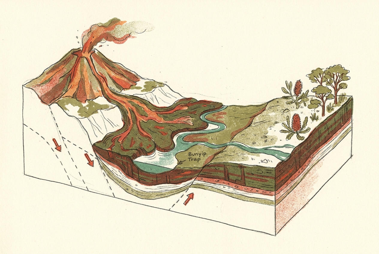
Victoria's Bunyip River valley preserves a 20-metre-thick lava flow from a 60-million-year-old fissure eruption that flooded river valleys and created the Mornington Peninsula's foundation.
Sixty million years ago, a crack opened in the earth southeast of Melbourne and poured out enough lava to bury a river system, fill ancient valleys to the brim, and leave behind a 20-metre-thick slab of basalt that still shapes the landscape today. The Bunyip Trap—named for the mythical creature said to haunt the nearby swamp—is not a single volcano but the remnant of a vast flood basalt eruption that followed Australia's slow separation from Antarctica.
The Fissure That Flooded a Valley
Unlike the cone-shaped volcanoes most of us picture, the Bunyip Trap erupted from a linear fissure—a long gash in the crust that released low-viscosity basalt lava in sustained pulses. The flows poured into an existing river valley carved into Cretaceous sandstone, filling it completely and then spilling over the edges. When the lava finally cooled, it preserved the valley's original shape as a negative impression: the basalt cap protected the softer sandstone beneath from erosion, while the surrounding landscape wore away.
Today, the Bunyip River cuts through the edge of this lava flow, exposing the contact where molten rock once met river gravel. The site lies within the Bunyip State Park, about 60 kilometres east of Melbourne, in the foothills of the Great Dividing Range. The basalt there is fine-grained, dark grey, and studded with small vesicles—gas bubbles that froze in place as the lava cooled.
The Gondwanan Context
The Bunyip Trap belongs to a much larger volcanic province that erupted along Australia's southern margin between 90 and 50 million years ago, during the final breakup of Gondwana. As the Australian plate rifted away from Antarctica, the stretching crust thinned and fractured, allowing magma from the underlying mantle to rise along weaknesses. This produced a chain of volcanic centres stretching from Victoria's Otway Basin across to Tasmania and beyond.
The timing is precise. Radiometric dating of the Bunyip basalt gives an age of about 60 million years—early Paleocene, just after the extinction of the dinosaurs. At that time, the Mornington Peninsula was still connected to Tasmania, and the Bass Strait did not yet exist. The landscape was warm and wet, dominated by podocarp forests and the first flowering plants.
The lava did not build a mountain. It filled a hole, and the hole became a ridge.
What the Trap Preserves
The Bunyip Trap is geologically significant because it preserves a complete valley-filling lava sequence in cross-section. Most flood basalts erode unevenly, leaving only scraps. Here, the river has cut a clean window through the flow, exposing the base, the interior columnar jointing, and the weathered upper surface.
The lower contact shows baked and reddened sandstone—the heat of the lava metamorphosed the riverbed sediments into a brick-like material called hornfels. Above that, the basalt forms rough columns, the classic hexagonal cracks that develop as thick lava cools and contracts. The top of the flow is deeply weathered, turned to red clay soil that supports the park's tall eucalypt forest.
The Inverted Landscape
The Bunyip Trap is a textbook example of what geomorphologists call inverted relief. The lava filled a low valley; erosion then removed the surrounding softer rock, leaving the basalt standing as a high ridge. What was once a depression is now a plateau.
Walk along the Bunyip River track today, and you are walking on the floor of a 60-million-year-old river that no longer exists. The actual river has shifted sideways, cutting a new channel beside its own fossilised predecessor. The inversion is so complete that the modern Bunyip River flows in a gorge below the ancient lava-filled valley, a quiet demonstration of how rock outlasts water.
More like this
- The 110-Million-Year-Old River That Runs Backwards UndergroundWestern Australia's 110-million-year-old dune system has been slowly dissolving into a labyrinth of caves where an ancient river still flows, carrying the taste of a Cretaceous desert.
- The 5,000-Year-Old Volcanoes That Still Smoke in the SouthIn Victoria's Newer Volcanics Province, 400 volcanic vents erupted as recently as 5,000 years ago—the youngest volcanic field in mainland Australia, where craters still hold blue lakes and scoria cone
- The 300-Million-Year-Old Forest That Died Standing UpIn New South Wales, a 300-million-year-old fossil forest preserves dozens of trees buried upright by a Permian volcanic eruption—an entire ecosystem frozen in ash.