12 May 2026 · 4 min read
The Mud That Became Mountains: The Flinders Ranges' Adelaide Geosyncline
The Flinders Ranges of South Australia preserve a 700-million-year story of rifting, sedimentation, and compression that turned ancient seafloor mud into towering quartzite ridges.
Seven hundred million years ago, the place that would become the Flinders Ranges was a wound. The supercontinent Rodinia was tearing apart, and a deep rift valley opened across what is now South Australia. Into that rift, for 200 million years, sediment poured: sand, silt, mud, and the occasional blanket of glacial debris. What began as a gash in the Earth's crust became a basin called the Adelaide Geosyncline, and what filled that basin would later be squeezed into some of the most spectacular mountain ranges on the continent.
The Basin That Wouldn't Stay Flat
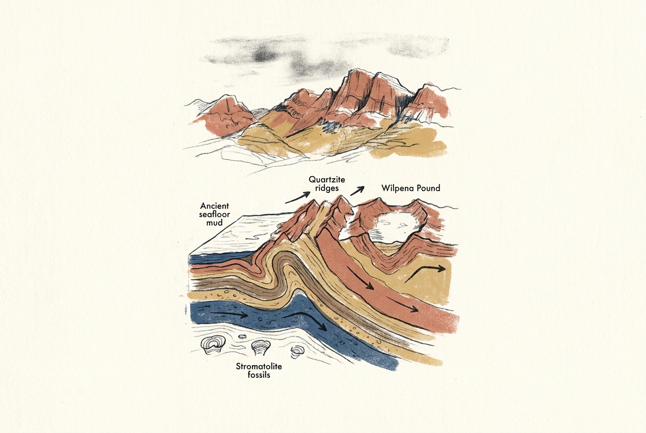
The Adelaide Geosyncline was not a single trough but a complex of sub-basins that accumulated sediment from three distinct sources. From the west came erosion of the Gawler Craton, a block of ancient Proterozoic crust. From the east and north came material shed from other highlands that no longer exist. The sediment pile grew thick—more than 10 kilometres in places.
The rocks that formed tell a precise story. The Sturt Tillite, a layer of lithified glacial debris, records a Snowball Earth glaciation around 660 million years ago. Above it lie the Brachina and Bunyeroo formations, fine-grained siltstones that settled in quiet, deep water. Higher still, the ABC Range Quartzite preserves beach sands from a shallow sea that advanced and retreated repeatedly.
These formations are not abstract names on a map. Walk through Wilpena Pound, the great natural amphitheatre at the heart of the ranges, and you walk up through time. The Pound's outer walls are quartzite—the cemented sand of ancient beaches—while its interior is carved from softer shales and siltstones that erode more easily. The entire landscape is a cross-section of a long-vanished seafloor.
The Squeeze That Made Mountains
Around 500 million years ago, the rifting stopped and the compression began. A tectonic event called the Delamerian Orogeny folded and faulted the entire Adelaide Geosyncline. The basin, full of sediment, was shortened horizontally by at least 50 percent. Layers that had been flat became vertical. Mud became slate. Sand became quartzite. The seafloor rose into mountains.
This is why the Flinders Ranges look the way they do. The ridges are not random; they are the eroded edges of folded rock layers, tilted on end and exposed like the pages of a book left in the rain. The famous zigzag pattern visible from the air, especially around the town of Blinman, traces the crests of anticlines and the troughs of synclines—the original folds of the orogeny, now etched by 500 million years of erosion.
The mountains we see today are not the mountains that rose. They are the roots of those mountains, exposed after the peaks weathered away.
The Reefs That Survived
Not all of the sediment in the Adelaide Geosyncline was sand and mud. In the shallow waters of the ancient rift, microbial communities built reef-like structures called stromatolites. Today, these are preserved as the Skillogalee Dolomite, a grey carbonate rock that crops out in the northern Flinders Ranges.
The stromatolites of the Skillogalee Formation are about 800 million years old—older than the Ediacaran fossils found elsewhere in the same ranges, and far older than any animal-built reef. They are not spectacular to the untrained eye: layered domes of rock, a few metres across, that resemble cabbages turned to stone. But they record something profound. For most of Earth's history, microbial mats were the only builders of solid structures. The Skillogalee stromatolites are a reminder that the Flinders Ranges contain not just a story of mountains, but a story of life.
The Landscape Today
The Flinders Ranges stretch 430 kilometres from Crystal Brook in the south to Lake Callabonna in the north. The highest point, St Mary Peak, reaches 1,171 metres. But elevation is not the point. What matters is the exposure: the rocks lie bare, stripped of soil by a dry climate, revealing their internal structure with unusual clarity.
The Brachina Gorge Geological Trail, a 20-kilometre drive through the central ranges, passes through nearly 200 million years of Earth history in a single afternoon. You start in the oldest rocks, near the gorge entrance, and drive forward in time as you head east. The formations appear in order: Sturt Tillite, Brachina Formation, Bunyeroo Formation, ABC Range Quartzite. Each layer is a page, and the gorge has cut through the book.
The ranges are still rising, very slowly. Australia's northward drift continues to generate stress in the crust, and the old faults of the Delamerian Orogeny occasionally reactivate. In 2022, a magnitude 5.0 earthquake near the town of Hawker briefly shook the same rocks that had been folded half a billion years earlier. The Flinders Ranges are not a finished story. They are still being written.
More like this
- The 110-Million-Year-Old River That Runs Backwards UndergroundWestern Australia's 110-million-year-old dune system has been slowly dissolving into a labyrinth of caves where an ancient river still flows, carrying the taste of a Cretaceous desert.
- The 5,000-Year-Old Volcanoes That Still Smoke in the SouthIn Victoria's Newer Volcanics Province, 400 volcanic vents erupted as recently as 5,000 years ago—the youngest volcanic field in mainland Australia, where craters still hold blue lakes and scoria cone
- The 560-Million-Year-Old Garden That Never Saw a PredatorIn South Australia's Flinders Ranges, 560-million-year-old Ediacara surfaces preserve entire seafloor communities of fronds, discs, and quilts — a garden of soft-bodied life that flourished before pre