14 May 2026 · 4 min read
The Glass Beaches of Port Campbell: Seafloor That Became Cliffs
Victoria's Port Campbell coast preserves 15-million-year-old limestone full of trillions of microfossils, then shattered by volcanic explosions into a ragged shoreline of sea stacks and arches.
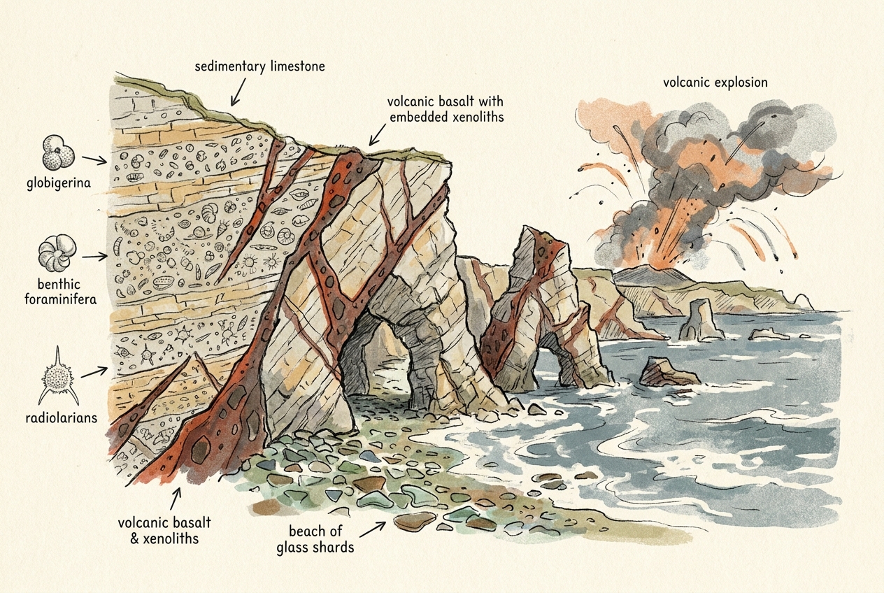
On Victoria's Shipwreck Coast, the limestone cliffs glow white under a southern sun. But these are not ordinary sedimentary beds. The Port Campbell limestone is made almost entirely of the microscopic skeletons of single-celled algae—coccolithophores—that rained onto a shallow seafloor 15 million years ago. Trillions upon trillions of them, accumulating grain by grain into a rock that later became a stage for one of Australia's most dramatic volcanic encounters.
The Chalk That Wasn't
The limestone of the Port Campbell region belongs to the Port Campbell Limestone formation, deposited during the Middle Miocene, roughly 15 to 10 million years ago. At that time, southern Australia sat further south, and the shallow seas that covered what is now Victoria teemed with coccolithophores—tiny marine algae that build shells of calcium carbonate.
When these organisms died, their skeletons drifted to the seafloor like fine snow. Over millions of years, the accumulated sediment compacted into a soft, white limestone unusually pure in composition. Unlike the famous white cliffs of Dover, which formed from similar organisms but in the Cretaceous, Port Campbell's cliffs are younger and less consolidated—softer, more easily carved by waves.
The rock holds a precise record of Miocene ocean chemistry. Oxygen isotopes trapped in the coccolith shells reveal sea surface temperatures and salinity levels from an era when Antarctica was still partially forested and global carbon dioxide concentrations were higher than today.
The Lava That Met the Sea
About 5 million years ago, in the Late Miocene to Pliocene, a different kind of activity began. The Newer Volcanic Province—the same system that later produced Victoria's 400 eruption points—sent magma up through fissures along the coast. Where rising basalt met the soft, water-saturated limestone, the contact was explosive.
Steam blasted through the rock, shattering both lava and limestone into angular fragments. These explosions created maar volcanoes—broad, shallow craters formed when groundwater flashed to steam upon contact with magma. The craters are now visible as circular bays indenting the coastline, including the famous Loch Ard Gorge and the Grotto.
At several points along the coast, basalt intruded directly into the limestone as dykes and sills. The contrast between the dark, hard volcanic rock and the pale, soft sedimentary rock defines the shoreline's visual character. Where the limestone has eroded more quickly, the basalt remains as resistant ribs and platforms.
The Architecture of Collapse
The Port Campbell coast is a study in differential erosion. The soft limestone erodes readily, but not uniformly. Joints and fractures in the rock—some inherited from the volcanic shattering, others from regional stress—create lines of weakness that waves exploit.
Sea stacks like the Twelve Apostles are the most famous result. Each stack began as part of the cliff line. Waves carved a cave into a zone of weakness, then the cave broke through to form an arch, and finally the arch collapsed, leaving an isolated pillar of limestone standing offshore. The process continues today: in 2005, one of the Apostles collapsed into the sea.
The rate of cliff retreat here averages about 2 to 5 centimetres per year, though storm events can remove metres in a single day. The limestone cliffs are not old, geologically speaking—they will be gone entirely within tens of thousands of years, eroded back to expose the underlying volcanic rocks.
The Twelve Apostles are not permanent landmarks. They are moments in a process, caught between deposition and destruction.
The Record in the Rock
The Port Campbell limestone holds more than just coccoliths. Scattered through the rock are the fossils of larger Miocene organisms: scallop shells, sea urchin spines, crab claws, and the teeth of sharks that once patrolled these warm seas. Fossil whale bones have been found, including those of ancient baleen whales that migrated through the Southern Ocean.
The volcanic horizons also preserve information. The basalt contains phenocrysts of olivine and pyroxene that can be dated using potassium-argon methods, giving precise ages for the eruptions. These dates reveal that volcanic activity along this coast was episodic, with pulses of eruption separated by quiet intervals of hundreds of thousands of years.
One of the most striking features is London Bridge, a natural arch that was once a double-arched bridge of limestone connecting to the mainland. In 1990, the arch nearest the mainland collapsed, stranding two tourists on the outer section. The collapse followed the same pattern that created the Apostles: erosion along a joint plane, undercutting until the rock could no longer support its own weight.
The Future of a Coastline
The Port Campbell coast is transient on every timescale. The limestone itself represents a 5-million-year window of biological productivity in the Miocene. The volcanic overprint represents a few hundred thousand years of tectonic and magmatic activity. The present landscape—the arches, stacks, and blowholes—represents perhaps the last 10,000 years of Holocene sea-level rise.
Projections suggest that within the next century, rising sea levels and increased storm intensity will accelerate cliff retreat. Several of the remaining Apostles may collapse. New stacks will form as existing headlands are carved through. The coastline will shift inland, and the basalt intrusions that now form resistant platforms will become the new shoreline.
None of this is unusual. It is the normal behaviour of a dynamic coastline built from the bodies of ancient algae and reshaped by fire and water. The Port Campbell cliffs are not a static monument to the past. They are a snapshot of a process that began 15 million years ago and will continue until the last grain of coccolith shell has been carried back to the sea.
More like this
- The 5,000-Year-Old Volcanoes That Still Smoke in the SouthIn Victoria's Newer Volcanics Province, 400 volcanic vents erupted as recently as 5,000 years ago—the youngest volcanic field in mainland Australia, where craters still hold blue lakes and scoria cone
- The 560-Million-Year-Old Garden That Never Saw a PredatorIn South Australia's Flinders Ranges, 560-million-year-old Ediacara surfaces preserve entire seafloor communities of fronds, discs, and quilts — a garden of soft-bodied life that flourished before pre
- The 300-Million-Year-Old Forest That Died Standing UpIn New South Wales, a 300-million-year-old fossil forest preserves dozens of trees buried upright by a Permian volcanic eruption—an entire ecosystem frozen in ash.