10 May 2026 · 4 min read
The Fused Shore: The Granites of the Bunger Hills
In Antarctica's Bunger Hills, 1.2-billion-year-old Australian granite reveals when two continents were one, fused by the same tectonic collision that built the Albany-Fraser Orogen.
On the coast of East Antarctica, at 66 degrees south, a range of low granite hills rises from the ice. The rock is pale, coarse-grained, veined with pink feldspar. It looks like it belongs in Western Australia. It does.
The Bunger Hills are a piece of Australia that wandered south.
The Missing Piece
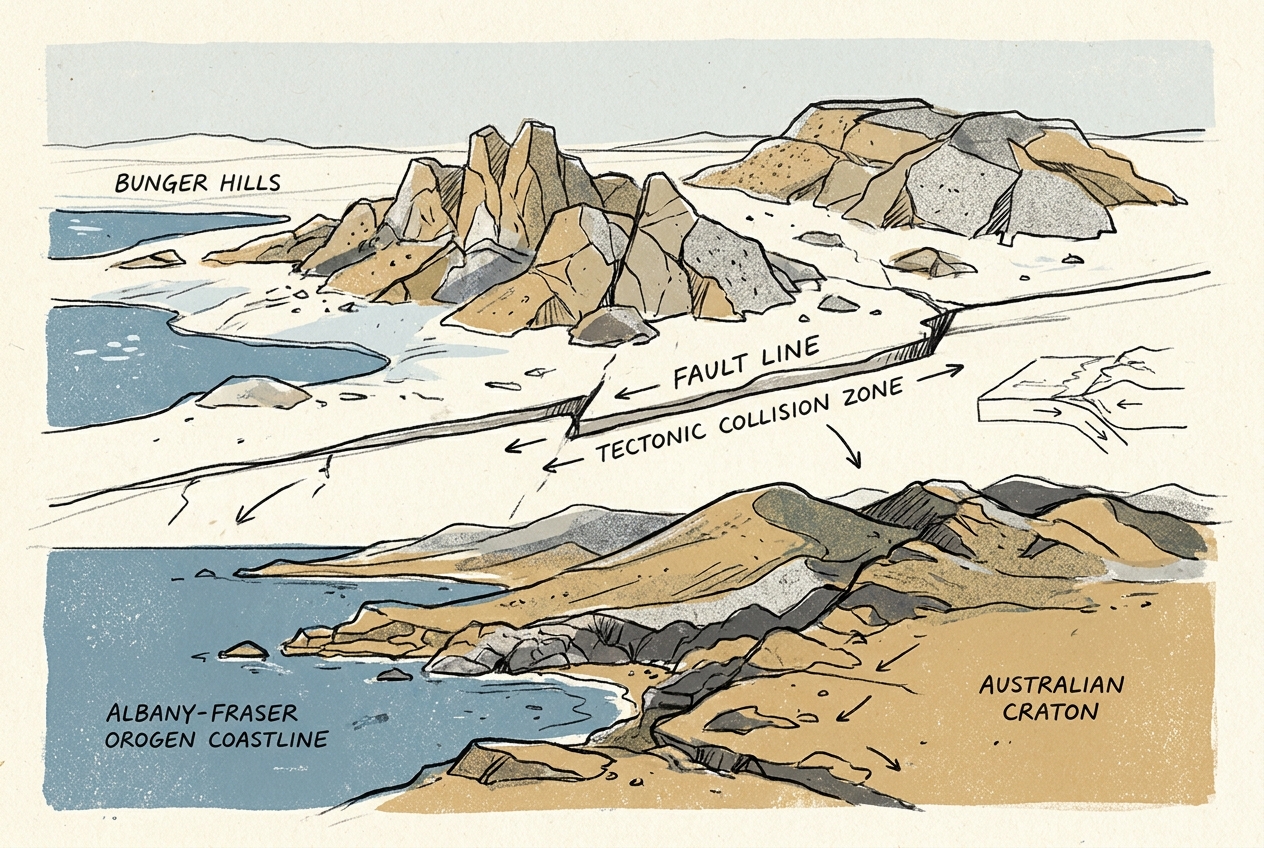
When geologists first mapped the Bunger Hills in the 1950s, they noticed something odd. The granites and gneisses matched those of the Albany-Fraser Orogen, the 1.2-billion-year-old collision zone that runs along Australia's southern coast between Esperance and Ceduna. Not just similar—identical. Same mineral composition. Same deformation patterns. Same age of cooling and exhumation.
The Albany-Fraser Orogen formed when the Yilgarn Craton (the ancient heart of southwest Australia) collided with the Gawler Craton (the core of South Australia), welding them into a single continent. But the orogen does not end at the Australian coast. It continues offshore, beneath the Southern Ocean, and reappears 2,000 kilometres to the south in the Bunger Hills of Antarctica.
The link was confirmed in the 1970s, when plate-tectonic reconstructions showed that Australia and Antarctica were joined until roughly 45 million years ago. The Bunger Hills were the missing piece of the puzzle—the part of the Albany-Fraser belt that stayed behind when Gondwana broke apart.
The Granite Itself
The Bunger Hills are not particularly dramatic. They rise only a few hundred metres above the ice. The glaciers that once covered them have retreated, leaving behind a landscape of bare rock, meltwater ponds, and erratic boulders. But the granite tells a story of deep time.
The rock crystallised about 1.2 billion years ago, when the collision between cratons generated immense heat and pressure, melting the lower crust. Magma rose slowly, cooling over millions of years into the coarse-grained granite visible today. The pink feldspar crystals, some as long as a finger, grew in the quiet interval between the collision's peak and the final solidification.
Later, the granite was exhumed—brought back to the surface by erosion and tectonic uplift. By the time the first Antarctic ice sheets advanced, roughly 34 million years ago, the Bunger Hills were already a landscape of rounded domes and weathered joints, much as they appear today.
The granite was born in the heart of a supercontinent, then split in two by the slow machinery of plate tectonics. The other half still sits on the south coast of Australia.
The Split
The separation of Australia and Antarctica began around 85 million years ago, when the two continents started to rift apart along a zone of weakness that followed the old suture lines of the Albany-Fraser Orogen. The rifting took tens of millions of years. By 45 million years ago, the last continental connections had broken, and the Southern Ocean opened between them.
The Bunger Hills, which had been part of the Australian continental mass for over a billion years, were carried south on the Antarctic Plate. The Albany-Fraser Orogen was sliced in two. Australia kept the northern half, along the coast between Esperance and the Nullarbor. Antarctica kept the southern half, in the Bunger Hills and the adjacent Windmill Islands.
Today, the two halves are separated by 3,000 kilometres of ocean. But the rock remembers.
The Living Record
The Bunger Hills are one of the few places in Antarctica where large areas of bedrock are exposed, free of permanent ice. This makes them a natural laboratory for studying how the East Antarctic Ice Sheet has behaved over millions of years. The granite surfaces preserve glacial striations—scratches carved by rocks embedded in the base of moving ice—that record the direction and thickness of past ice flow.
Some of these striations were cut by the massive ice sheet that covered the hills during the Last Glacial Maximum, 20,000 years ago. Others are older, perhaps dating to the Miocene, when the ice sheet first expanded to its current size. The granite weathers slowly; it keeps its scratches for millions of years.
The Bunger Hills also record the present. As the climate warms, the ice around the hills is thinning. New areas of bedrock are emerging, exposing fresh surfaces that have not seen sunlight in tens of thousands of years. Geologists are racing to sample them before the evidence of past ice cover is lost to meltwater and lichen.
The granite of the Bunger Hills is a quiet archive—of a continent that broke in two, of ice that came and went, of a billion-year journey from the deep crust to the Antarctic coast. It asks nothing of us. It simply waits, pink and patient, for someone to read its grain.
More like this
- The 450-Million-Year-Old Volcano That Holds the Great Barrier ReefThe Great Barrier Reef grows on the eroded stumps of a 450-million-year-old volcanic arc that forms its hidden foundation.
- The 110-Million-Year-Old River That Runs Backwards UndergroundWestern Australia's 110-million-year-old dune system has been slowly dissolving into a labyrinth of caves where an ancient river still flows, carrying the taste of a Cretaceous desert.
- The 5,000-Year-Old Volcanoes That Still Smoke in the SouthIn Victoria's Newer Volcanics Province, 400 volcanic vents erupted as recently as 5,000 years ago—the youngest volcanic field in mainland Australia, where craters still hold blue lakes and scoria cone