16 May 2026 · 4 min read
The Buried Rift That Split a Continent: Perth's Darling Fault
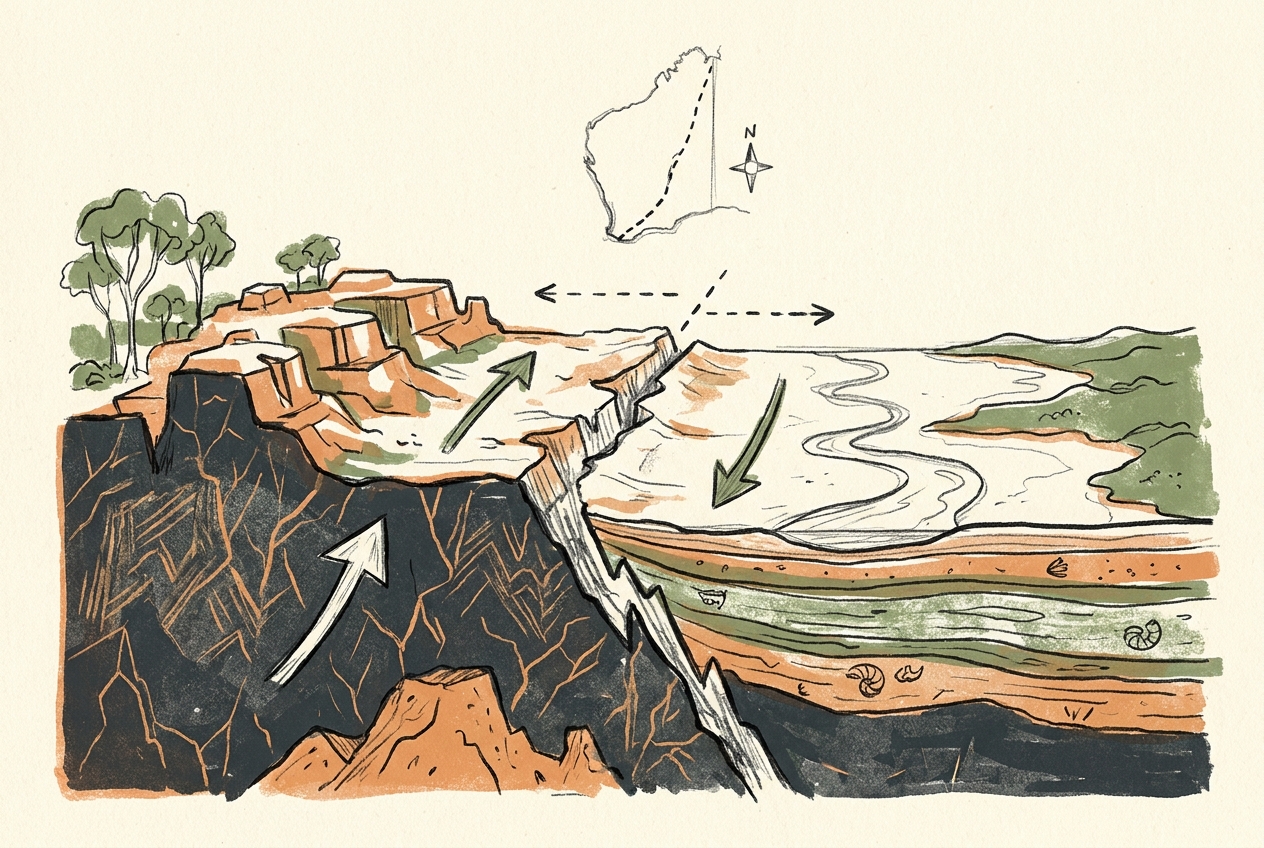
The Darling Fault in Western Australia records a 1.3-billion-year history from crustal fracture to escarpment, where ancient bedrock meets younger sediments along a 1,000-kilometre scar.
The Darling Fault runs for 1,000 kilometres along the western edge of Australia, a near-vertical crack in the continent's crust. On one side of the line sits some of the oldest rock on Earth. On the other side lies sediment deposited just yesterday, geologically speaking. The fault does not shout; it escarpments.
The line is visible from space. West of the fault, the Perth Basin holds kilometres of sand and limestone laid down over the past 500 million years. East of it, the Yilgarn Craton—a block of granite and greenstone up to 3.7 billion years old—rises as the Darling Scarp, a low but abrupt cliff that runs north-south like a continental spine.
The Crack That Wouldn't Heal
The Darling Fault began as a rift. Around 1.3 billion years ago, the crust beneath what is now Western Australia started to pull apart. Stretching thinned the rock until it snapped. One side dropped; the other stayed high. This is the classic anatomy of a normal fault: a hanging wall that falls, a footwall that rises.
But unlike most rifts, this one never healed into a full ocean basin. The spreading stopped, leaving a half-formed scar. For the next 800 million years, the fault sat dormant, buried under sediment eroded from the Yilgarn's high ground. Then, around 500 million years ago, during the assembly of the supercontinent Gondwana, the fault reactivated. Compression pushed the Yilgarn block upward again, like a piano lid lifting on slow hinges. The Darling Scarp was born.
The fault is so old that the rocks on either side have never been the same age.
What makes the Darling Fault unusual is its patience. Most continental rifts either evolve into spreading ridges or are destroyed by later tectonics. This one simply waited. The escarpment we see today is not the original fault plane but a retreating cliff line, eroded westward by 15 to 30 kilometres over hundreds of millions of years. The actual fault trace lies buried beneath the Perth Basin's coastal plain.
The Two Worlds of the Scarp
Stand on the Darling Scarp at sunset and you can see the divide clearly. To the east, the Yilgarn Craton stretches flat and ancient—a landscape of weathered granite domes, salt lakes, and lateritic duricrust. This is a surface that has sat above sea level for most of the past 500 million years, slowly rotting in place. To the west, the Perth Basin sinks toward the Indian Ocean, its younger sediments holding the groundwater that supplies the city of two million people.
The contrast is not just visual. The Yilgarn's ancient rocks are barren of the phosphorus and nitrogen that young soils contain. The Perth Basin's sands, by contrast, are rich in weathered minerals and support the region's pine plantations and market gardens. The fault is a geological border that became an agricultural and economic one.
A City Built on the Line
Perth sits exactly on the fault. The city's eastern suburbs climb the scarp's slopes; its western suburbs spread across the basin's sandy flats. The Darling Scarp provides Perth with its most dramatic natural feature—a sudden wall of granite and laterite rising 200 to 300 metres above the coastal plain.
The fault is still active, though barely. Earthquakes of magnitude 3 to 4 occur along the scarp every few years, releasing the stress that builds as the Australian plate drifts northward at 7 centimetres per year. In 2018, a magnitude 5.7 quake near Lake Muir, 300 kilometres south of Perth, ruptured along a splay of the Darling Fault system. The shaking damaged buildings in the city and reminded residents that the quiet scarp is still a live tectonic boundary.
What the Scarp Reveals
The Darling Fault exposes a cross-section of the continent's deep history. In the road cuts along the scarp, you can see the contact: grey Yilgarn granite against yellow Perth Basin sandstone, separated by a thin zone of crushed and ground-up rock called fault gouge. That gouge is the actual surface where one side slipped past the other, polished by movement over deep time.
Geologists have drilled into the fault zone to understand its structure. They found that the damage zone—the region of fractured rock surrounding the fault plane—extends over a kilometre wide. This shattered rock acts as a conduit for groundwater, which is why the scarp's eastern side hosts springs and soaks even during dry summers. The fault is a water pipe as much as a tectonic scar.
The Darling Fault is not the most famous geological feature in Australia. It lacks the grandeur of Uluru or the drama of the Great Barrier Reef. But it is the quiet hinge on which the western third of the continent turns—a 1.3-billion-year-old crack that never quite closed, still shaping the line between ancient and young, high and low, dry and wet.
More like this
- The 110-Million-Year-Old River That Runs Backwards UndergroundWestern Australia's 110-million-year-old dune system has been slowly dissolving into a labyrinth of caves where an ancient river still flows, carrying the taste of a Cretaceous desert.
- The 5,000-Year-Old Volcanoes That Still Smoke in the SouthIn Victoria's Newer Volcanics Province, 400 volcanic vents erupted as recently as 5,000 years ago—the youngest volcanic field in mainland Australia, where craters still hold blue lakes and scoria cone
- The 1.75-Billion-Year-Old Reef That Outranks the BarrierA 1.75-billion-year-old microbial reef in the Kimberley is the largest biological structure ever built by a single species, preserving a world without predators.