13 May 2026 · 3 min read
The Ash That Made the Land: Tasmania's Jurassic Dolerite Cracks
How 180-million-year-old magma, injected into Tasmania's crust as vertical sheets, eroded into the island's most distinctive landscape—and why it almost reached Antarctica.
On the east coast of Tasmania, a mountain called the Organ Pipes rises not as a single peak but as a row of vertical stone columns, each one a five-sided pillar of dark grey rock. They look like a giant church organ carved by a sculptor with no interest in ornament. In fact, they are the exposed interior of a magma chamber that never erupted.
The Intrusion That Stayed Put
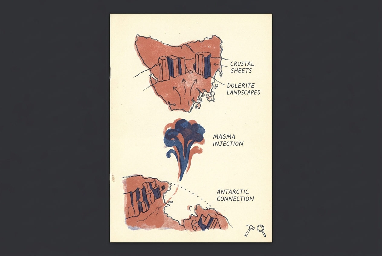
Around 180 million years ago, as the supercontinent Gondwana began to feel the stresses that would eventually tear it apart, a vast pulse of basaltic magma rose from deep within the Earth. But instead of breaking through to the surface as a volcanic eruption, this magma got stuck. It forced its way between layers of existing sedimentary rock—fracturing, melting, and baking the older sandstone and mudstone around it—and then cooled slowly, kilometres underground.
What formed was not a single dome but a series of flat sheets (sills) and vertical walls (dykes) that together make up the Jurassic dolerite province of Tasmania. This is one of the largest such provinces on Earth. The dolerite covers about a third of the island's surface area, though it formed entirely underground. Only later did erosion strip away the softer rocks above, exposing the hard, dark dolerite as the new landscape.
The Organ Pipes at Mount Wellington, overlooking Hobart, are a classic example. The columns formed as the cooling magma contracted, cracking into hexagonal and pentagonal prisms—the same process that creates columnar basalt at places like the Giant's Causeway, but here the rock cooled far more slowly, deeper down.
A Landscape Etched by Cold and Time
What makes Tasmania's dolerite landscapes distinctive is not just their origin but their weathering. The rock is dense and tough, but it fractures along joint lines. Over millions of years, water seeps into these cracks, freezes, and wedges the stone apart. The result is a terrain of blocky tors, steep scree slopes, and flat-topped plateaus that look like ruins of a lost civilisation.
The Central Plateau, a high, windswept expanse of dolerite blocks and shallow lakes, was shaped this way. During Pleistocene glaciations, ice sheets scraped across the plateau, plucking blocks of dolerite and leaving behind a jumble of boulder fields. The stone itself resisted the grinding better than the surrounding sedimentary rock, so it now stands as the dominant highland.
"The dolerite is the bone of Tasmania. Everything else has been worn away."
The Gondwana Connection
The same Jurassic magma event that filled Tasmania's crust also left its mark across the rest of Gondwana. Dolerite sheets of identical age and composition appear in South Africa (the Karoo), Antarctica (the Ferrar large igneous province), and South America. Before the continents drifted apart, this single magma pulse spread across an area of roughly 3 million square kilometres.
Tasmania sits at the hinge point. Its dolerite province is the missing link between the Karoo and Ferrar provinces, a geological fingerprint of the same deep mantle plume that prefigured the breakup of Gondwana. When you stand on the Organ Pipes, you are standing on a piece of a supercontinent that no longer exists—exposed not by violence but by patient erosion.
The Rock That Builds
Tasmanians have used dolerite for two centuries. It forms the dark grey stone walls of Hobart's oldest buildings, the kerbs of its streets, the breakwaters of its harbours. The stone is hard to shape but nearly indestructible. It weathers to a rusty brown patina, but it does not crumble.
There is a quiet irony in this. The magma that once sat deep and hidden, never seeing the sun, now forms the most visible rock on the island. It is the skeleton of Tasmania, the buried fire that became a landscape.
More like this
- The 110-Million-Year-Old River That Runs Backwards UndergroundWestern Australia's 110-million-year-old dune system has been slowly dissolving into a labyrinth of caves where an ancient river still flows, carrying the taste of a Cretaceous desert.
- The 5,000-Year-Old Volcanoes That Still Smoke in the SouthIn Victoria's Newer Volcanics Province, 400 volcanic vents erupted as recently as 5,000 years ago—the youngest volcanic field in mainland Australia, where craters still hold blue lakes and scoria cone
- The 1.75-Billion-Year-Old Reef That Outranks the BarrierA 1.75-billion-year-old microbial reef in the Kimberley is the largest biological structure ever built by a single species, preserving a world without predators.